North Australia Railway
This section contains information about the North Australia Railway (NAR). The NAR ran from Palmerston (Darwin) in the north to Pine Creek in south. It was 234km (145 miles 78 chains) long, opened on 1.10.1889 and officially closed 14.2.1981.
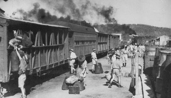
The NORTH AUSTRALIA RAILWAY was the name given to the Northern Territory 3 ft. 6 in. gauge railway that extended south from Darwin to Birdum. The South Australian Government commenced this line, known then as the Palmerston to Pine Creek Railway, and opened it in 1889. When the administration of the Northern Territory passed from South Australia to the Commonwealth Government on 1 January 1911 the railway was transferred to Commonwealth ownership, under the control of the Administrator of the Northern Territory. At this time it was known as the Northern Territory Railway, but was transferred to the control of the Commonwealth Railways Commissioner in 1918. Prior to this date the Commonwealth Railways seemed to have exercised a large influence over decisions about the railway, as well as providing some locomotives and other rollingstock. It was renamed the North Australia Railway in 1926 and extensions to Birdum were completed in 1929, but during and following World War II the effective railhead was Larrimah, a few miles north.
The railway gained increased importance in the 1960's and early 70's through the haulage of iron ore from the Frances Creek deposits, about 140 miles south of Darwin. Ore traffic exceeded one million tons per annum, but unfortunately world ore prices dropped forcing the mine to close and other traffic was not enough to justify keeping the railway open. The line eventually ceased all operations in 1976.
Stokes Hill Jetty -- Town Jetty
| 1887 | First jetty (timber) completed. [jh nnl] |
| 1897 | Timber jetty closed because it was in danger of collapse. [jh nnl] |
| 1898 | Construction of new iron jetty commensed - it was reported completed a decade later. [jh nnl] |
| 1922 | One rail track along the bridge section replaced by a cattle race to facilitate of live beasts. [jh nnl] |
| 1930s | A small side jetty built leading to the eastern side of the bridge and used as a flying boat terminal. [jh nnl] |
| 19.2.1942 | Part of the bridge section destroyed by Japanese air-raid. [jh nnl] |
| 1942 | Army engineers built a temporary bridge to enable loading to continue.[jh nnl] |
| 1957 | New concrete wharf replaced Stokes Hill Wharf. [jh nnl] |
Boom Jetty
| 1941 | A substantial depot was built at the foot of Fort Hill with a shallow draught concrete jetty. It was connected by a spur line which ran from the Darwin yard. [jh nnl] |
Palmerston (0 m) -- Darwin (0 m) -- Frances Bay Freight Yard (0 m)
| - | Orinally named Palmerston |
| - | Renamed Darwin |
| 1926 | Railway/Government store and siding built. [jh nnl] |
| 1934 | Sorting Shed (Bond Store) burnt down and replaced by a more modern structure [jh nnl] |
| 11.1972 | Major collision between ore train and NJ engines in yard. |
| 1973 | Yard renamed to "Frances Bay Freight Yard". [jh nnl] |
Petrol Sidings (Peel Street) (0 m 73 c)
| WWII | Army petrol station and distribution centre for Darwin. [jh nnl] |
| before 1963 | Sidings disconnected. [jh nnl] |
Public Works Vacuum and Naval Victualling Sidings (1 m 51 c)
| 1914 | Noted a Government Works Store at this location[jh nnl] |
| 1926 | Abolished when new storehouse built in the Darwin Yard. [jh nnl] |
| 1930s | Siding estabilshed to serve Vacuum Oil. [jh nnl] |
| WWII | Additional siding built at location to serve the Naval Victualling Store. [jh nnl] |
| 1963 | Tank siding Disconnected. [jh nnl] |
| 1967 | Navalsiding Disconnected. [jh nnl] |
One and Half Mile (1½ m)
| 1932 | One and Half Mile - Mentioned in general Appendix [GA] |
B.I.O. Co. Oil Store
| 1932 | B.I.O. Co. Oil Store - Mentioned in general Appendix [GA] |
Parap (2 m)
| - | Triangle junction built to serve the Meat Works siding. The junction was in the form of a triangle to enable cattle trains from the south to enter and frozen carcasses to process to Darwin without reversing.[jh nnl] |
| 1950s | Meat Works siding removed. Triangle retained as a reversing point for diesel electric locomotives. [jh nnl] |
North Australia Meat Company Ltd -- Vestey"s Siding (2 m 63c)
| 1918 | Knowen as Vestey"s Siding [jh nnl] |
| 1932 | North Australia Meat Company Ltd. - Mentioned in general Appendix [GA] |
| 1950s | Meat Works siding removed - the remnants of the branch used as a private siding by the Hastings Deering Co., to unload earth moving machinery. [jh nnl] |
| - | [jh nnl] |
Locomotive Depot and Workshops -- 2½ Mile (Old Loco) (2 m 40c)
| 1917 | Staff Station opened [jh nnl] |
| 1917 | Staff Station closed [jh nnl] |
Three Miles (3 m)
| 1918 | Cattle trucking yards installed on the up side of main line [jh nnl] |
RAAF Siding (6 m 07c)
| WWII | Spur siding leading to to the RAAF base at the up end of the Winnellie Loop [jh nnl] |
| 1950s | A triangle was built leading off the spur. This was used to reverse trains and unload wagons of stone from Darwin River. [jh nnl] |
Winnellie (6 m 51 c)
| WWII | Loop Siding of 633 feet established. [jh nnl] |
Knuckey"s Lagoon (10 m 10 c)
| - | Siding 600 feet in length. [jh nnl] |
| 1967 | Siding extended to 1335 feet. [jh nnl] |
Southport Road
| 1932 | Southport Road - Mentioned in general Appendix [GA] |
McMinns (20 m 2 c)
| - | Loop siding of 689 feet. [jh nnl] |
| 1967 | Loop extended to 2104 feet. [jh nnl] |
22 Mile (22 m) -- Wishart (22 m)
| - | Appears in some working time tables as a stopping spot without loop - a number of fettlers cotages were here as headquarters for a maintenance gang. [jh nnl] |
| - | Nmaed "Wishart" after a contractor who built the first Palmerston jetty. [jh nnl] |
Millar (22 m 50c)
| 1968 | Loading point for iron ore from Mount Bundey mine. [jh nnl] |
| 1972 | Siding was disconnected. [jh nnl] |
Firdan (27 m 17c)
| WWII | Siding near Stuart Highway that served the Army field supply depot. The siding was 2350 feet in length. [jh nnl] |
| by 1973 | Consisted of a crossing loop only of 3630 feet. [jh nnl] |
Noonamah (29 m 16c)
| WWII | War time facility that consisted of a triangle on the down side to serve as a RAAF depot.[jh nnl] |
| - | Closed shortly after the end of WWII[jh nnl] |
Southport (37 m 54 c)
| - | Original SAR loop siding of 650 feet. [jh nnl] |
| 1958 | Shown as a crossing place. [jh nnl] |
Darwin River (42 m 56 c)
| - | Water spot during steam days [jh nnl] |
| 1952 | Triangle installed on down side to act as loading point for quarry rubble used for construction of Darwin RAAF base [jh nnl] |
| by 1958 | Shown as a crossing place[jh nnl] |
| 1968 | Siding used to store surplus cattle wagons [jh nnl] |
Beetson (46 m 28 c)
| 1915 | Fettlers camp established [jh nnl] |
| WWII | Site of 800 foor crossing loop [jh nnl] |
| 1967 | Loop extended to 2530 feet.[jh nnl] |
Rum Jungle (56 m 42 c)
| - | SAR station with a single loop siding of 669 feet.[jh nnl] |
58 Mile camp (58 m)
| 1932 | Listed in General Appendix as a Fettlers Camp [jh nnl] |
Batchelor (60 m 20 c)
| 1912 | Station established to server "Batchelor Demonstration Farm". Consisted of a loop siding of 477 feet [jh nnl] |
| WWII | Loop extended by 624 feet and a petrol unloading point installed [jh nnl] |
| 1950-60s | Used as the loading point by the Rum Jungle uranium and cooper mines[jh nnl] |
| 1967 | Reverted to a simple loop siding of 2081 feet [jh nnl] |
Simms (62 m 57 c)
| 1943 | Crossing station with 800 foot loop [jh nnl] |
Ballast Siding (67 m)
| - | Millars second ballast pit was located here. [jh nnl] |
| WWII | Dead end siding installed. [jh nnl] |
Stapleton Creek (69 m 24 c) -- Stapleton (69 m 24 c)
| - | Original SAR station known as "Stapleton Creek" [jh nnl] |
| by WWII | Loop length 1122 feet. [jh nnl] |
| by 1973 | Loop extended to 2409 feet.[jh nnl] |
Snake Creek (74 m 55 c)
| 1942 | Siding built to serve large Naval Armaments Depot [jh nnl] |
| 1969 | Siding disconnected from main line [jh nnl] |
Adelaide River North (76 m)
| WWII | Served the Army's main supply base [jh nnl] |
Adelaide River (76 m 72 c)
| 1925 | Yard extended - triangle, cattle yards and loading race installed at the northern end [jh nnl] |
| WWII | Two additional roads and a spur to stable ambulance installed [jh nnl] |
| 1967 | Layout simplified and the crossing loop extended to 2060 feet [jh nnl] |
Goodilla (86 m 27 c)
| - | Opened with the line to Pine Creek [jh nnl] |
| 1918 | Closed [jh nnl] |
| WWII | Reinstalled with a loop of 800 feet[jh nnl] |
| Post WWII | Turnouts removed [jh nnl] |
| 1967 | Loop restored with a length of 1888 feet [jh nnl] |
88 Mile (88 m)
| 1918 | Copper ore loading at this point on the main line [jh nnl] |
Howley (100 m 37c)
| - | Original SAR three road station with 700 foot sidings [jh nnl] |
| 1967 | Reduced to a single crossing loop of 2343 feet [jh nnl] |
Brock"s Creek (103 m 70c)
| - | Established to serve the nearby Zatopan mine and Brock's Creek township - loop siding of 300 feet [jh nnl] |
| WWII | RAAF aviation spirit depot [jh nnl] |
Fountain Head (107 m 66 c)
| - | Original three road SAR station with 700 foot sidings [jh nnl] |
| 1916 | Cattle yards and loading race installed [jh nnl] |
| 1967 | Yard reduced to a single loop siding of 1600 feet. [jh nnl] |
112 Mile (112 m)
| - | Site of Fettlers cottages [jh nnl] |
Grove Hill (113 m 25 c)
| - | Original three road SAR station with 700 foot sidings [jh nnl] |
Burrundie (123 m 67 c)
| - | Original three road SAR station with 700 foot sidings [jh nnl] |
| 1967 | Loop extended to 2104 feet. [jh nnl] |
Boomleera (131 m 10 c)
| - | Original three road SAR station with 700 foot sidings [jh nnl] |
| WWII | Shown as having a loop of 900 feet [jh nnl] |
134½ Mile (134 m 40 c) -- Roney (134 m 40 c)
| - | Juction for the 10 mile spur line serving the Frances Creek ore mine [jh nnl] |
| 11.1966 | Named "Roney" [jh nnl] |
Frances Creek (145 m)
| 1966 | Opended as loading point for ore on the Frances Creek Ore mine spur line [jh nnl] |
| 1975 | Closed [jh nnl] |
Lady Alice Camp (135 m 44 c)
| before 1918 | Site of Fettlers cottages and ore mine [jh nnl] |
Union Reefs (138 m 32 c)
| - | Original three road SAR station with 700 foot sidings [jh nnl] |
Pine Creek (145 m 78c)
| 1914 | Yard enlarged by the construction of additional sidings [jh nnl] |
Cullen (160 m 36 c)
| 1917 | Established as a stopping place with waiting shed when Emungalan extension opened. [jh nnl] |
| WWII | Crossing loop of 900 feet installed [jh nnl] |
Fergusson River (165 m 60c)
| 1917 | Shown as a water stop for locomotives [jh nnl] |
Horseshoe Creek (169 m 58 c)
| - | Loop siding of 761 feet [jh nnl] |
Edith River (175 m 78 c)
| 1924 | Opened as a loading point for stone used in the construction of the Katherine River bridge [jh nnl] |
| 1927 | Closed [jh nnl] |
| WWII | Loop siding installed [jh nnl] |
| - | Loop siding disconnected [jh nnl] |
| 1970 | Loop siding reconnected [jh nnl] |
Helling (183 m 59 c)
| WWII | Crossing loop of 800 feet[jh nnl] |
191 Mile (191 m)
| 1932 | Listed as a Fettlers camp [jh nnl] |
Emungalan (199 m 18 c)
| 1917 | Terminus of the line [jh nnl] |
| 1926 | Abolished when Katherine station opened [jh nnl] |
| WWII | Crossing loop of 528 feet installed [jh nnl] |
| 1969 | Loop removed [jh nnl] |
Katherine Loco (200 m 49c)
| 1942 | Site of the Evacuated Workshops and locomotive running depot [jh nnl] |
| 10.1948 | Workshops moved back to Darwin [jh nnl] |
Katherine (200 m 65c)
| 1926 | Opened after completion of Katherine River bridge [jh nnl] |
| WWII | Spur siding of 1352 feet installed [jh nnl] |
Katherine Old Loco (201m 21 c)
| 1926 | Construction siding built to serve as the depot for the Birdum extension [jh nnl] |
| 1942 | Original site of the Evacuated Workshops [jh nnl] |
Katherine South (202 m 34 c)
| WWII | Petrol unloading point and crossing loop of 600 feet [jh nnl] |
| 1973 | Loop extended to 2155 feet [jh nnl] |
Tindal (208 m 60 c)
| 1960s | Established to serve the RAAF base [jh nnl] |
Blain (214 m 19 c)
| WWII | Crossing loop of 800 feet [jh nnl] |
Marranboy (230 m 41 c)
| 1928 | Opened as a loop of 830 feet [jh nnl] |
Collings (246 m 47 c)
| WWII | Loop siding of 900 feet [jh nnl] |
Mataranka (264 m 52 c)
| 1.7.1928 | Terminus of Line [jh nnl] |
| 4.9.1929 | Line extention beyond Mataranka opened [jh nnl] |
Elsey (280 m 75 c)
| WWII | Crossing loop of 900 feet [jh nnl] |
Hobler (296 m 36 c)
| WWII | Crossing loop of 900 feet [jh nnl] |
Gorrie (303 m 4 c)
| WWII | Crossing loop of 900 feet [jh nnl] |
Larrimah (311 m 22 c)
| - | Site of the Army transit camp [jh nnl] |
| 1958 | Became the operation end of the line when a triangle was installed. [jh nnl] |
Petrol Sidings (311 m 56 c)
| WWII | Established as the major fuel transhipment point. [jh nnl] |
Birdum (316 m 17 c)
| 4.9.1929 | Opened as the terminus of the line [jh nnl] |
| 1958 | Ceased to be a functional station as all services terminate at "Larrimah" [jh nnl] |
